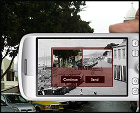
 Pedro Teixeira’s graduation project in the MSc in Computer Science at the University of Madeira aimed to make old photographs available on mobile devices and, making use of GPS functionality, helping the user to find the exact location where these photographs were taken.
The designed and developed application targets Android devices and offers three modes for locating photographs. In a map view, the user finds an overview of nearby located photographs that are accessible through the online archive. Using the map, one can navigate to this location. Once in the neighbourhood, the photograph can be seen in the augmented reality view (using the devices in the upright position), which places the photograph in an iconic representation in the 3D space registered on the device using its camera. When the user is really near the photograph’s location, the image will ‘snap’ to the display in semi-transparency and the user can move to the exact location where the camera’s image and photograph overlay, showing ‘then’ and ‘now’ in a matched view.
